It was August 1814. Panic held New York in thrall.
After two years of incoherent fighting, the War of 1812 was being waged in deadly earnest. No longer preoccupied with the Emperor Napoleon, who had been forced to abdicate the French throne, Britain trained its full military might on the ill-prepared United States. British troops captured Washington, setting fire to the Capitol and the White House. Twilight’s last gleaming was fast approaching in Baltimore. And the enemy’s control of Lake Champlain made clear that its route to New York City would be from the poorly defended north......
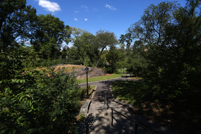
A landscaping project in Central Park uncovered traces of 200-year-old fortifications. Roughly at the center of the photograph was the site of a gatehouse at McGowan's Pass.
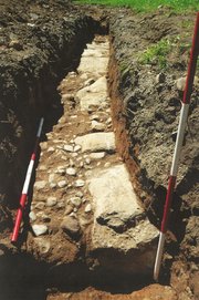 A drainage trench in which the foundation of the gatehouse (large stones) and part of the Kingsbridge Road (small stones) were found.
 It was August 1814. Panic held New York in thrall.
After two years of incoherent fighting, the War of 1812 was being waged in deadly earnest. No longer preoccupied with the Emperor Napoleon, who had been forced to abdicate the French throne, Britain trained its full military might on the ill-prepared United States. British troops captured Washington, setting fire to the Capitol and the White House. Twilight’s last gleaming was fast approaching in Baltimore. And the enemy’s control of Lake Champlain made clear that its route to New York City would be from the poorly defended north.
Kingsbridge Road, a rudimentary highway that ran from the mainland down Manhattan Island to New York City, suddenly looked like an invasion route.
Pressed into wartime duty, civilians fashioned impromptu fortifications wherever redcoats might appear, includingMcGowan’s Pass in Harlem, through which anyone on the Kingsbridge Road would have to travel to reach New York.
On the north side of the pass, the citizens drilled a line of holes into a rock outcropping. Iron rods inserted in those holes could have been used to help build a defensive wall linking three small fortifications — Fort Clinton,Nutter’s Battery and Fort Fish — that guarded the pass and the surrounding countryside.
The British never came. And over time, the fortifications disappeared.
But you can still see the holes that were drilled in fearful haste 200 years ago.
They are just some of the surprising physical traces of the War of 1812, including a short stretch of the Kingsbridge Road itself, found by the Central Park Conservancy during a recently completed reconstruction of the Fort Landscape in the north end of the park. Within the landscape, McGowan’s Pass is in the hillocks south of the Harlem Meer.
The $2 million project was not driven by a desire to uncover the past. But because it involved digging up paths and installing new utilities in an area known to be rich in history, conservancy officials wanted to avoid any excavation missteps.
They hired Hunter Research to examine plans of the proposed work, identify any potential areas of conflict and then physically explore any area where historical fabric might remain. The work was led by Richard W. Hunter, the president and principal archaeologist of Hunter Research, and Jim Lee, the principal investigator. They dug exploratory holes and trenches in 2013.
One trench revealed the foundations for the southeast side of a gatehouse that had been constructed, almost like a bridge, across McGowan’s Pass and over the Kingsbridge Road.
The investigation also revealed secrets hidden in plain sight. On a rock outcropping about 20 feet northwest of a stairway leading to the pass were several sharply delineated cylindrical scars, an inch or more in diameter. These are remnants of a stone splitting technique known as plug-and-feather, Dr. Hunter said. The Harlem fortifications were built atop the very rock from which they were composed. It was a convenient quarry when time was of the essence.
Another set of quarry scars can be seen on an outcropping at the opposite side of the pathway. About 40 feet due west, across this large rock outcropping, are eight holes in a line. (Dr. Hunter said there were nine, but the ninth was hard to spot.)
The holes may not have had a role in building the redoubt. They may simply have been started for a quarrying operation that was never finished. Or they may have been made at another time altogether and for a different purpose. However, Dr. Hunter said, “When you superimpose them on the historical maps, they are exactly where the defenses would be.”
Easily the most thrilling discovery occurred during the excavation of a 70-foot-long trench for a new drain pipe. There, a couple of feet under the soil, were the foundations for the northwest side of the gatehouse and a section of the bed of the Kingsbridge Road, made of smaller stones.
To conserve this find in place, a membrane of permeable geotextile was laid atop the historical stonework. The drainage pipe was set down over that, and the whole area was paved over. No visible evidence remains.
“We have learned so much more about this area of the park, particularly what was going on before the park was built,” said Marie R. Warsh, director of preservation planning for the conversancy, a nonprofit organization that manages Central Park under contract with the city.
“This wasn’t an archaeology project for the sake of archaeology,” she said. “It was an archaeology project for the sake of stewardship. Not that we weren’t excited by what we found.”
Source: http://www.nytimes.com/2014/09/25/nyregion/excavated-in-central-park-traces-of-the-war-of-1812.html?smid=fb-nytimes&smtyp=cur&bicmp=AD&bicmlukp=WT.mc_id&bicmst=1409232722000&bicmet=1419773522000&_r=0

 RSS Feed